


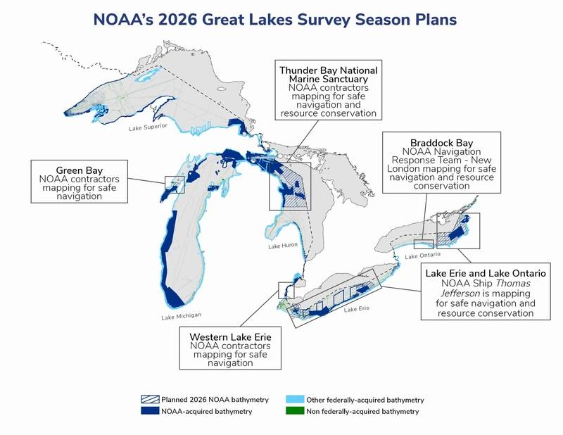
For the first time since 2022, the NOAA Ship Thomas Jefferson is underway in the Great Lakes. The vessel and its crew of NOAA Corps officers and professional mariners are working with
For the first time since 2022, the NOAA Ship Thomas Jefferson is underway in the Great Lakes. The vessel and its crew of NOAA Corps officers and professional mariners are working with NOAA scientists to map the waters of western and central Lake Erie and eastern Lake Ontario this year to improve navigation safety. Survey work will also occur within Lake Ontario National Marine Sanctuary to identify critical habitats located within the area.
Western Lake Erie, one of the shallowest areas within the Great Lakes marine transportation system, is highly trafficked by commercial and recreational vessels and has not been surveyed since the 1940s. NOAA’s nautical navigation products and services from seafloor mapping surveys are critical for a safe, and secure ocean economy. These tools reduce collisions, identify dangers to navigation, and facilitate more efficient and successful fishing operations.
 NOAA’s Great Lakes survey season plans for 2026. © NOAA
The Great Lakes are the least mapped region of the U.S., making this work even more important for mariners in the region. In addition to operations on larger vessels like the Thomas Jefferson, NOAA also maps critical areas of the Great Lakes each year using navigation response teams. This year, those teams
Content Original Link:
" target="_blank">


 Q1 2026 Earnings Call Transcript")


